Vancouver, British Columbia – February 4th, 2021 – Exploits Discovery Corp. (“Exploits” or the “Company”) (CSE: NFLD) (OTCQB: RNRRF) (FSE: 634-FF) is pleased to announce the results of its Spatiotemporal Geochemical Hydrocarbon (SGH) soil grid, displaying three distinct gold responses missed by historic drilling. Surface sampling returned one sample grading 16 g/t Au.
Highlights
- Three distinct areas of anomalous SGH gold signature were highlighted. The distribution of the gold anomalies match our current modelling of True Grit gold mineralization, and adds untested targets to the east of the historic drillout.
- Historic shallow and broad gold mineralized drill intercepts, including 0.60 g/t Au over 117m from surface, occur on the fringes of the anomaly, indicating the main anomalous bodies were not tested.
- While there is very little outcrop exposure at True Grit, one quartz vein in outcrop was found and sampled in the fall of 2020 which returned a value of 16 g/t Au, trending west-northwest, similar in appearance and orientation to the gold mineralized D3 veins along the GRUB Line found at Exploits’ Jonathan’s Pond Project.
- 2,830 line kilometers of high resolution airborne VTEM geophysics currently being flown over True Grit will provide structural context to the SGH gold anomalies, similar to the discovery process used by Great Bear Resources at their Dixie project. Additionally, Exploits will be utilizing GoldSpot Discoveries A.I. to assist in generating clear targets for further exploration and drilling.
- The historic drilling, SGH and outcrop sampling data will be used to build a 3-D model and define drilling targets.
Michael Collins, President and Chief Executive Officer of Exploits, commented: “These results move the True Grit project up in our drill target ranking within our Exploits Subzone project. While we want to build our 3-D model of True Grit mineralization with the integration of the Airborne Magnetics and Electromagnetic data before applying for drill permits, these results support our preliminary model for drilling and making a discovery on the True Grit project.”
The SGH soil campaign at True Grit consisted of 1,041 samples at 25 metre intervals along 100 metre line spacing to target structurally controlled, epizonal orogenic gold mineralization on the project. The SGH grid covered historic gold in till sampling, historic shallow drilling with broadly gold mineralized intercepts, and extended to cover the Gander River Ultramafic Belt (GRUB) Line fault zone, as interpreted by regional geophysics. The results of the SGH soil grid highlights three distinct areas where the geochemical hydrocarbon signal related to gold mineralization are present in abundance.
True Grit SGH Results
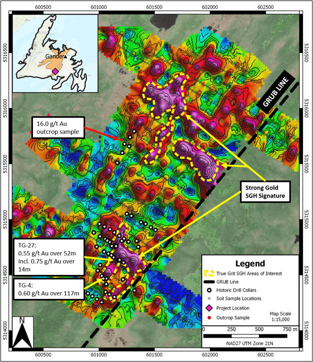
Figure 1: Map of the True Grit SGH soil sample results with historic drilling overlain. Areas of pink correspond with samples that measure high in geochemical hydrocarbons that are related to gold, with blues indicating no geochemical hydrocarbons related to gold in the sample.
The southern area partially coincides with historic drill results including 0.60 g/t Au over 117 metres from surface, and 0.55 g/t Au over 52 metres, including an interval of 0.75 g/t Au over 14 metres (Moydow Mines, 2005). These shallow, broadly gold mineralized intercepts validate the SGH method as it proves there is gold in the ground; however, the intercepts are spatially located on the fringes of the SGH gold signature, and are oriented west-northwest off of the anomaly; resulting in the highest targets within the signature are remaining to be tested.
The northern two SGH anomalies lie where there has been little to no drilling. A single drilling campaign by Moydow Mines in 2005 targeted a gold in till anomaly which returned no significant assays. These drill holes coincide with an area of null to low SGH gold signatures, suggesting that the gold in tills that the drilling targeted were mobilized from their source. During sampling, a quartz vein in outcrop was discovered returning an assay of 16.0 g/t Au. The quartz vein was mapped having a west-northwest (~295 deg), steeply dipping orientation, similar to the eastern SGH gold signature which could provide evidence for this being a prospective structural orientation for gold mineralization. The quartz vein is also sub-parallel to the drilling, which also indicates that the drill orientations were not optimal for intersecting gold mineralized quartz veins in this orientation.
Currently, Exploits is flying 2,830 line kilometers in an airborne VTEM geophysical survey at 100 metre line spacing over the True Grit project. High resolution geophysics paired with SGH results was a big part of the successful exploration model Great Bear Resources (TSX.V: GBR) used for their Dixie Project discovery. Data from the survey is being uploaded in real time for the Company’s in-house team and partner, GoldSpot Discoveries (TSX.V: SPOT), to process and understand the structural component of the project. This will provide the anomalous SGH gold signatures with clear structural context in which to target for discovery.
About the SGH Survey
Actlabs describes the SGH survey as follows: “Actlabs’ Spatiotemporal Geochemical Hydrocarbon (SGH) analysis is a high-performance deep penetrating geochemistry which has successfully shown the presence of deeply buried mineral deposits. The survey technique involves the collection of near surface soils, peat, humus, till, and sand in the field and then desorbing the weakly bound heavy hydrocarbons in the C5-C17 carbon series range at the laboratory from sample material. The desorbed organic compounds are collected and introduced into a Gas Chromatograph/Mass Spectrometer (GC/MS) where over 160 of these heavier hydrocarbon compounds are measured. The analysis identifies a mixture of hydrocarbon compounds that provide a highly confident, unique fingerprint that identifies mineralization under thick cover. Measurements do not recognize inorganic content in the samples; therefore, the results do not reflect mobilized anomalies or any nugget affect. SGH in tandem with geophysics is a cost-effective technique to improve drill targeting success.”
National Instrument 43-101 disclosure
Ian Herbranson, P.Geo, is Vice-President of Exploration for the company and qualified person as defined by National Instrument 43-101. Mr. Herbranson supervised the preparation of the technical information in this news release.
Quality Assurance – Quality Control
The Exploits exploration program design is consistent with industry best practices and the program is carried out by qualified persons employing a quality assurance/quality control program consistent with National Instrument 43-101.
All soil samples are collected by company personnel and bagged in the field with a sample tag for identification. The bags are sealed with zip ties and kept secure at a company facility until they are transported directly via a commercial shipping company. Samples are shipped in rice bags with security tags which are verified upon delivery to the lab.
All SGH soil samples are analyzed at Activation Laboratories of 41 Bittern Street, Ancaster, Ontario, a commercial laboratory that is ISO/IEC 17025 accredited and completely independent of Exploits Discovery Corp. All reported soil samples were analyzed by SGH techniques and instruments, with results interpreted by the lab.
About Exploits Discovery Corp.
Exploits Discovery is a Canadian mineral exploration company focused on the acquisition and development of mineral projects in Newfoundland, Canada. The Company currently holds the Jonathan’s Pond, Dog Bay, Mt. Peyton, Middle Ridge, True Grit, Great Bend and Gazeebow projects which cumulatively cover an area of approximately 2,111 square kilometres.
All projects within Exploits’ portfolio lie within the Exploits Subzone.
Exploits believes that the Exploits Subzone, which runs 200 km from Dog Bay southwest to Bay d’Espoir, has been neglected since the last major exploration campaigns in the 1980s. The last 40 years have seen incremental advancements in the understanding of gold mineralization in the camp. The sum of this knowledge is now coming together in discrete and effective exploration models that have delivered discovery such as New Found Gold’s 2019 discovery of 92.86 g/t Au over 19.0 metres near surface. The Exploits Subzone and GRUB regions have been the focus of major staking and financing throughout 2020, with increased exploration activities forecasted in the area moving into 2021.
The team at Exploits, with significant local experience and knowledge, have studied the entirety of the Exploits Subzone and picked individual land packages for staking or joint venture where there is an opportunity for world class discoveries and mine development. Exploits intends to leverage its local team and the larger shift in understanding and become one of the most extensive explorers in the Exploits Subzone.
ON BEHALF OF THE BOARD
/s/ “Michael Collins ”
President and CEO
For further information, please contact:
Michael Collins, CEO
Tel: (604) 681-3170
Neither the Canadian Securities Exchange nor its Regulation Service Provider (as the term is defined in the policies of the Canadian Securities Exchange) accepts responsibility for the adequacy of accuracy of this news release.
Forward-Looking Statements
This news release contains certain forward-looking statements, which relate to future events or future performance and reflect management’s current expectations and assumptions. Such forward-looking statements reflect management’s current beliefs and are based on assumptions made by and information currently available to the Company. Readers are cautioned that these forward-looking statements are neither promises nor guarantees, and are subject to risks and uncertainties that may cause future results to differ materially from those expected including, but not limited to, market conditions, availability of financing, actual results of the Company’s exploration and other activities, environmental risks, future metal prices, operating risks, accidents, labor issues, delays in obtaining governmental approvals and permits, and other risks in the mining industry. All the forward-looking statements made in this news release are qualified by these cautionary statements and those in our continuous disclosure filings available on SEDAR at www.sedar.com. These forward-looking statements are made as of the date hereof and the Company does not assume any obligation to update or revise them to reflect new events or circumstances save as required by applicable law.
Acknowledgments
Exploits Discovery would like to acknowledge the financial support of the Junior Exploration Assistance Program from the Department of Natural Resources, Government of Newfoundland and Labrador.